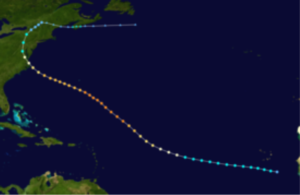
With Hurricane Season now less than a month away it might be good to review our history and look at some of the most destructive hurricanes to strike the Mid–Atlantic States starting with Hurricane #6 in 1933.
 The 1933 Chesapeake–Potomac hurricane was among the most damaging hurricanes in the Mid–Atlantic states in the eastern United States. The sixth storm and third hurricane of the very active1933 Atlantic hurricane season, it formed in the eastern Atlantic, where it moved west–northwestward and eventually became a Category 4 on the Saffir–Simpson hurricane wind scale. A strong ridge over New England allowed a continued northwest course, bringing the storm south of Bermuda and later toward the middle coast of the eastern United States. Advance warning allowed hundreds of people to evacuate ahead of the hurricane making landfall. It did so in northeastern North Carolina on August 23 with winds of about 90mph (150km/h). Soon after, the eye crossed over Norfolk, Virginia, the first time that happened since 1821. The hurricane weakened into a tropical storm over northern Virginia shortly before passing near Washington, D.C., becoming the worst tropical cyclone there since 1896. Curving northward, the storm moved through Pennsylvania and New York before losing tropical characteristics on August 25. Now extra tropical, the former hurricane moved across Atlantic Canada, dissipating on August 28.
Across the eastern United States, the hurricane left widespread damage amounting to over $40 million (equivalent to about $0.8 billion in 2020) and causing at least 47 deaths. Although the storm struck North Carolina, damage in the state totaled only about $250,000, largely to crops and transport. The storm produced 100–year flooding from its storm surge, setting records that remained for 70 years. In Virginia, flooding covered downtown portions of Norfolk in the southeast and Alexandria in the north. Damage in the state was estimated at $17.5 million. Similarly heavy damage occurred in Maryland, including over $7million to crops. High waves along the coast eroded beaches and created a new inlet at Ocean City. The highest rainfall associated with the hurricane was 13.28in (337mm) at York, Pennsylvania. In the state, the rains flooded several rivers which forced thousands to evacuate. In neighboring New Jersey, high waves wrecked boats and destroyed a fishing pier, while in New York, flooding caused traffic jams. In Atlantic Canada, heavy rainfall assisted firefighters in combating wildfires, and the associated winds caused isolated power outages.
Continuous weather records for the Hampton Roads Area of Virginia began on January 1, 1871 when the National Weather Service was established in downtown Norfolk. The recorded history of significant tropical storms that affected the area goes back much further. Prior to 1871, very early storms have been located in ship logs, newspaper accounts, history books, and countless other writings. The residents of coastal Virginia during Colonial times were very much aware of the weather. They were a people that lived near the water and largely derived their livelihood from the sea. To them, a tropical storm was indeed a noteworthy event. Learning from the past will help us prepare for the future.Please prepare now for the coming storm season.


